Captain VFR Release Update - July 24, 2025
CaptainVFR July 2025 update brings major improvements to flight planning, enhanced iOS compatibility, and new map visualization features for safer and more effi...
3 min read
release
update
+3
Create and manage VFR flight plans with automatic route calculations, waypoint management, and comprehensive flight planning tools
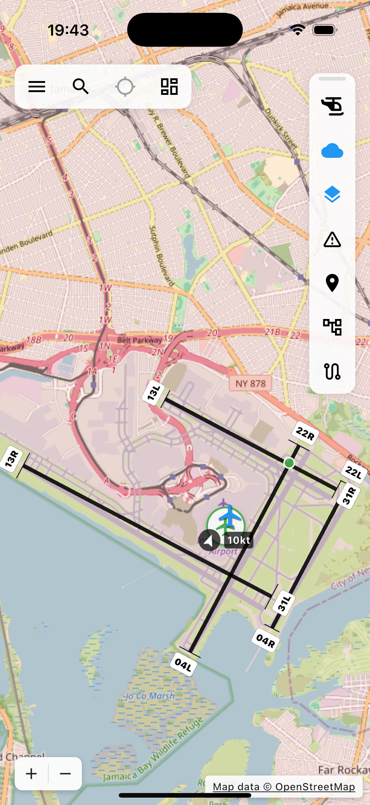
Professional Flight Planning
CaptainVFR transforms complex flight planning into an intuitive, visual experience. Whether you're planning a quick local flight or a cross-country adventure, our comprehensive flight planning tools give you everything you need to plan safe, efficient VFR flights with professional-level accuracy.

Intuitive Route Creation
Creating a flight plan has never been easier. Simply tap waypoints on the interactive map, and CaptainVFR instantly calculates distances, headings, and time estimates. Our intelligent route builder understands aviation navigation, automatically snapping to airports, navaids, and official reporting points while giving you complete freedom to customize your route exactly how you want it.

Comprehensive Waypoint Management
CaptainVFR supports all standard aviation waypoint types, from airports and navigation aids to visual reporting points and custom landmarks. Each waypoint type includes relevant information like frequencies, runway data, and facility details. Add personal notes to any waypoint to remember important details about that location for future flights.

Accurate Flight Calculations
Every flight plan includes comprehensive calculations based on your specific aircraft performance, current weather conditions, and planned routing. CaptainVFR automatically computes true and magnetic courses, adjusts for winds aloft, calculates fuel requirements with reserves, and provides realistic time estimates you can trust. All calculations update instantly as you modify your route or change aircraft.

Advanced Planning Features
Go beyond basic route planning with advanced features that help you plan for contingencies, comply with regulations, and optimize your flight. Designate alternate airports, plan for different cruising altitudes on each leg, export flight plans in standard formats, and integrate with weight & balance calculations to ensure your aircraft is properly loaded for the planned flight.

Flight Plan Library
Never plan the same route twice. CaptainVFR's flight plan library lets you save unlimited flight plans for future use, create templates for frequently flown routes, and organize your plans by region, purpose, or any system that works for you. Saved flight plans remember all your settings including waypoints, altitudes, and notes, making it quick and easy to repeat favorite flights or seasonal trips.

Import & Export Capabilities
CaptainVFR plays well with others. Import flight plans from other aviation apps, export your plans for use in different systems, and generate printable documents for your flight bag. Support for industry-standard formats like GPX and KML means you can move flight plans between CaptainVFR and virtually any other aviation or mapping application without losing data.

In-Flight Features
Flight planning doesn't stop when you take off. CaptainVFR's in-flight features keep your plan active and useful throughout your flight. See your planned route overlaid on the moving map, monitor your progress along the route, get real-time updates to your estimated arrival time, and quickly modify your plan if conditions change. The system continuously compares your actual flight to your plan, helping you stay on course and on schedule.

Emergency & Diversion Planning
When weather deteriorates, mechanical issues arise, or you simply need to land sooner than planned, CaptainVFR's diversion planning tools help you find the best alternate airport quickly. The system considers distance, runway length, available services, and current weather conditions to suggest suitable diversion airports. With one tap, you can route direct to any nearby airport and get instant calculations for distance, time, and fuel required.
"I had to divert for weather during a cross-country flight, and CaptainVFR made it completely stress-free. The nearest airport function showed me three good options with current weather, and I was able to route direct to my choice with one tap. The automatic fuel calculations confirmed I had plenty of reserve. This is exactly the kind of tool you want when things don't go as planned."
Join thousands of pilots who trust CaptainVFR for professional-grade flight planning. From quick local flights to complex cross-country adventures, our intuitive tools make flight planning faster, easier, and more accurate.
Explore our comprehensive library of articles, guides, and tutorials to deepen your understanding of key concepts and stay up-to-date with the latest developments.
CaptainVFR July 2025 update brings major improvements to flight planning, enhanced iOS compatibility, and new map visualization features for safer and more effi...

Maintain your pilot logbook digitally with automatic flight imports, comprehensive entry management, and easy export options for official records
Navigate with confidence using CaptainVFR's detailed aviation maps featuring real-time GPS tracking, airspaces, airports, and navigation aids